
'...may all our worlds be coloured in an absorbing geography' (MacDonald Gill 1944)

The Wonderground Map of London Town, 1914
MacDonald Gill (1884-1947) was a multi-talented man: an architect, letterer, mural painter and graphic designer. But in the public consciousness his name is inextricably linked with pictorial maps. The first he produced was a painted bird's eye perspective for a Lutyens country house in 1908, but it was his first poster map for the London Underground in 1914 that caught the attention of the press and public. By paying us your pennies or The Wonderground Map of London Town, as it later became known, was a gloriously comic depiction of London which, according to the Daily Sketch, amused passengers so much that they ‘miss their trains yet go on smiling’. The map depicts a capital peopled with quirky characters and is packed with jokes, puns, and verse alongside contemporary detail such as B-Type buses and a monoplane looping the loop. The heraldic borders with chevrons and Roman italics, however, hint at a medieval influence, the result of Max’s Arts and Crafts background.
The original quad-royal LU poster was printed in a two-sheet format, but in 1915 the Westminster Press published a folded linen-backed version in an attractive envelope specifically for selling to an eager public. Several smaller versions appeared in the twenties including the one most commonly found nowadays with its border message beginning: ‘The Heart of Britain’s Empire‘, issued in 1924 to coincide with the Wembley Empire Exhibition.

Theatreland, 1915
In all Max produced seven pictorial map posters for the London Underground, but I particularly like the following three. The first, Theatreland (1915), ingeniously presented as the pattern on a theatre curtain, seems a rather sombre portrait of the West End at night. But even in wartime Max could poke fun at a zeppelin attack, depicting his brother Eric warming his hands over the flames of a fire bomb! In contrast is the enchanting Peter Pan of Kensington Gardens (1923), a gaily-coloured fantasy based on J.M. Barrie’s classic tale set amongst the landmarks of London’s famous park. This and Max’s other LU maps all feature numerous references to friends and relations – most evidently in Country Bus Services (1928) which shows the Gill family, including the artist, playing cricket.

Highways of Empire, 1927
His poster maps for other organisations tended to be less detailed and more sober, yet despite the modern messages they promoted, they would always be enlivened with images of monstrous fish, heavenly bodies and galleons. A typical example is the Empire Marketing Board poster Highways of Empire (1927), a 20ft x 10ft map with a hemispherical projection resulting in two South Poles. On the day of its unveiling on the Charing Cross Road, this curiosity drew such crowds that the police were called! The EMB supplied thousands of a smaller version to schools around the country but few have survived.

Mail Steamship Routes, 1937
In the thirties the General Post Office commissioned Max to design three publicity maps. Perhaps the most popular - and now the most commonly found - is Mail Steamship Routes (1937) which depicts the journey of a letter from post-box to the other side of the world. Across the bottom of the map lies a series of roundels showing vessels from a Viking longship to RMS Queen Mary which probably tell us more about Max’s love of drawing ships than the mail transport!
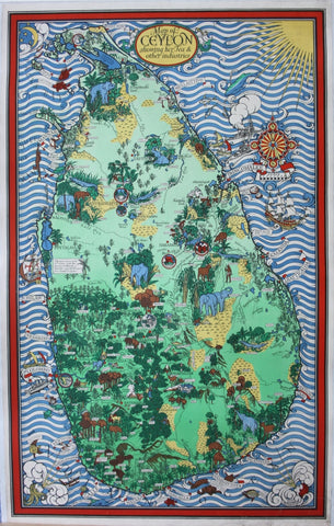
A Map of Ceylon, 1930s
In the same decade Max created several posters for the tea industry. A personal favourite is A Map of Ceylon showing her Tea and other industries, which pictures a multitude of exotic animals and plants. Another gem is Tea Revives the World (1940), a storehouse of fascinating information about our national drink.

Tea Revives the World, 1940
Only a handful of maps came after. These included three maps for the Ministry of Information, the Time & Tide Atlantic Charter Map in 1942 and Max's last, the Cable & Wireless Great Circle Map three years later. He died at the age of 62 in early 1947, a few months after completing a painted map for the Cunard liner RMS Elizabeth.

Great Circle Map, 1945
Caroline Walker (great-niece of MacDonald Gill)
You can find out more about MacDonald Gill and sign up for newsletters on Caroline Walker’s website www.macdonaldgill.com. A good source of information about his work for the London Underground can be found in Claire Dobbin’s excellent book London Underground Maps: Art, Design and Cartography (London, 2012). MacDonald Gill’s poster maps are well-represented in many UK collections including the British Library, the National Archives, the London Transport Museum and the V&A, though they are not usually on display.
A selection of original posters and resources by and about Macdonald Gill currently for sale can be viewed here.

Comments on post (2)
Carl Smith says:
I have a map, The “TIME&TIDE” map of THE ATLANTIC CHARTER,1942. It has been mounted on a hard backer board and has a few smaller blemishes on it. Everything is legible and there are no tears. The colors are good,but the several that I have found on line to compare to all have all have blue oceans and mine is decidedly more towards green oceans. I am hoping to get an idea of the value of this map. Any help will be greatly appreciated. Thank You, Carl Smith
Marina Marangos says:
Good afternoon, I am interested in finding a good copy of the highways of Empire poster. I wonder if you point me in the right direction. With thanks Marina Marangos
Leave a comment